

Applicability analysis of normalized difference vegetative index (NDVI) in grassland open-pit coal mine
-
摘要: 煤炭生產不可避免地會對生態環境造成影響,在煤炭生產中,生態環境監測是經濟可持續發展的重要環節。目前煤礦生態監測的最常見的方法是基于歸一化植被指數(NDVI)的植被覆蓋度計算,但在對露天礦的植被監測實驗中,基于NDVI的植被覆蓋度計算結果出現了的誤差。為了給草原礦區生態監測提供合適的方法,本文利用Sentinel-2數據采取遙感波段反演的方法計算了研究區的NDVI。并采取實證對比的方法對勝利、平朔礦區的NDVI分布特征進行了研究。結果表明:NDVI在具有一定植被覆蓋的區域能夠良好的反映地表植被覆蓋情況,但在礦區內部被煤炭覆蓋的區域可能會出現一定程度的誤差。誤差現象在兩個研究區均會出現,且在勝利礦區影響更加嚴重。推測誤差現象出現的原因是由于NDVI歸一化算法的不足導致僅使用NDVI為參數無法區分光譜曲線具有相似特征的煤炭覆蓋區域和中低覆蓋草地,因而建議在礦區植被監測中將相關區域進行掩膜處理或更換植被指數以避免此現象的影響。
-
關鍵詞:
- NDVI /
- 遙感植被監測 /
- 勝利礦區 /
- 平朔礦區 /
- Sentinel-2
Abstract: Coal production will inevitably have an impact on the ecological environment. It has become the consensus of all major countries that vegetation restoration should be carried out in coal mining areas. Monitoring the vegetation in the mining area is an important part of the vegetation restoration work in the mining area, and plays an important role in the design, implementation, management and maintenance of the vegetation work in the mining area. The calculation of vegetation coverage based on NDVI is currently the most common method of coal mine ecological monitoring. It was discovered during is the process that calculating vegetation coverage based on NDVI would cause serious errors. Sentinel-2 data was used to calculate the NDVI of the study area using the remote sensing band inversion method tostudy the reasons for the formation of the error zone and provide a suitable method for ecological monitoring of grassland mining areas. Furthermore, the empirical comparison method was used to investigate the NDVI distribution characteristics of the Shengli and Pingshuo mining areas. This phenomenon has also appeared in other research results. The results show that NDVI can accurately reflect the surface vegetation coverage in areas with specific vegetation coverage, but there will be significant error areas in coal-covered areas in the mining area. The error phenomenon will appear in both study areas, with a greater impact in the Shengli mining area. This error phenomenon is caused by the inadequacy of the NDVI’s normalization algorithm, which makes distinguishingbetween coal-covered areas and low-to-medium-covered grasslands with similar characteristics in spectral curves impossible. To avoid the impact of this phenomenon, we propose to mask the relevant areas or replace the vegetation index in the mining area’s vegetation monitoring.-
Key words:
- NDVI /
- remote sensing ecological monitoring /
- Shengli Coal Mine /
- Pingshuo Coal Mine /
- Sentinel-2
-
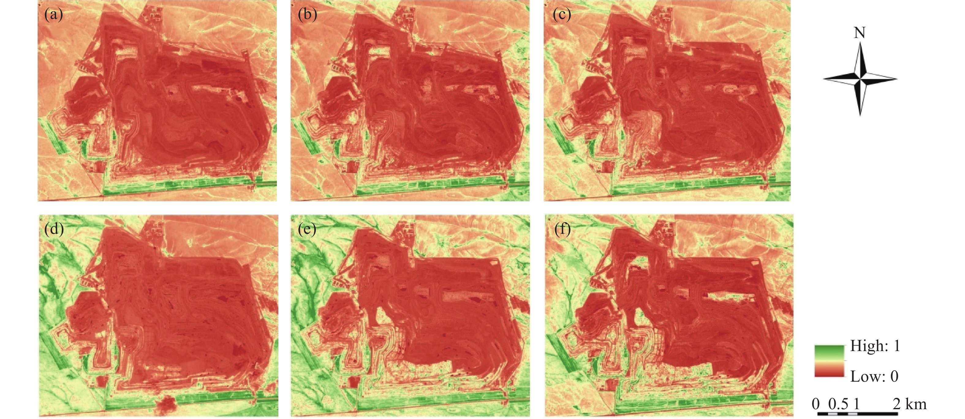
圖 2 勝利礦區2019、2020年夏季植被覆蓋度分布.(a)2019年7月;(b)2019年8月;(c)2019年9月;(d)2020年7月;(e)2020年8月;(f)2020年9月
Figure 2. Distribution of vegetation coverage in the summer of 2019 and 2020 in Shengli Coal Mine: (a) July 2019; (b) August 2019; (c) September 2019; (d) July 2020; (e) August 2020; (f) September 2020
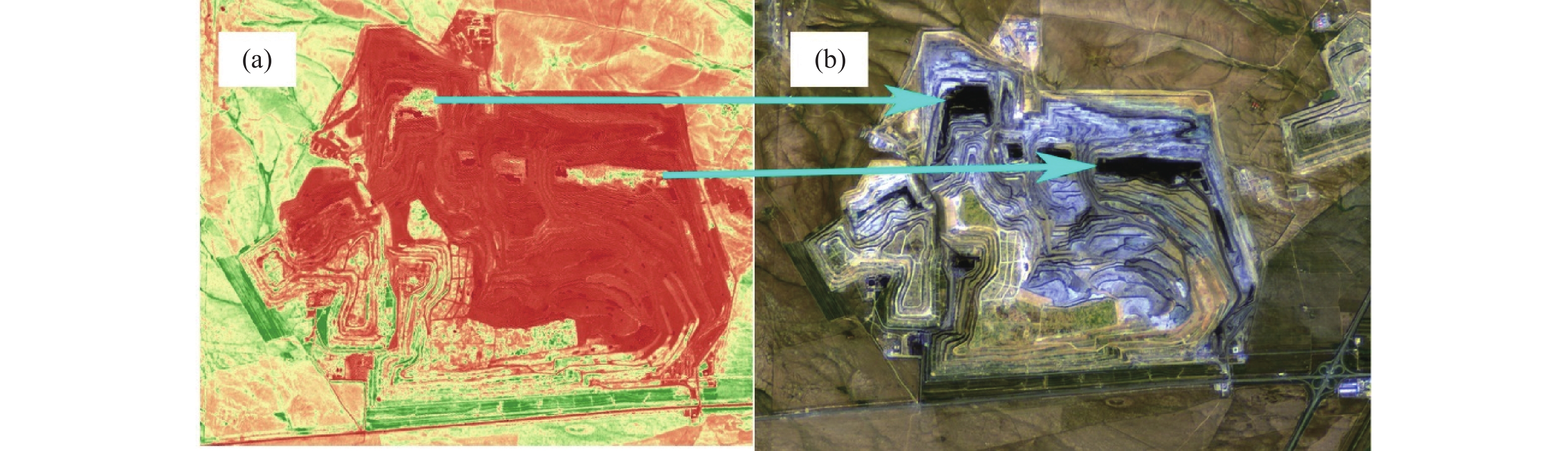
圖 3 基于NDVI的植被覆蓋度誤差區域. (a)植被覆蓋度分布;(b)遙感影像(2020年9月19日,真彩色合成)
Figure 3. Vegetation coverage error area based on NDVI: (a) vegetation coverage distribution; (b) remote sensing image (September 19, 2020, true color synthesis)
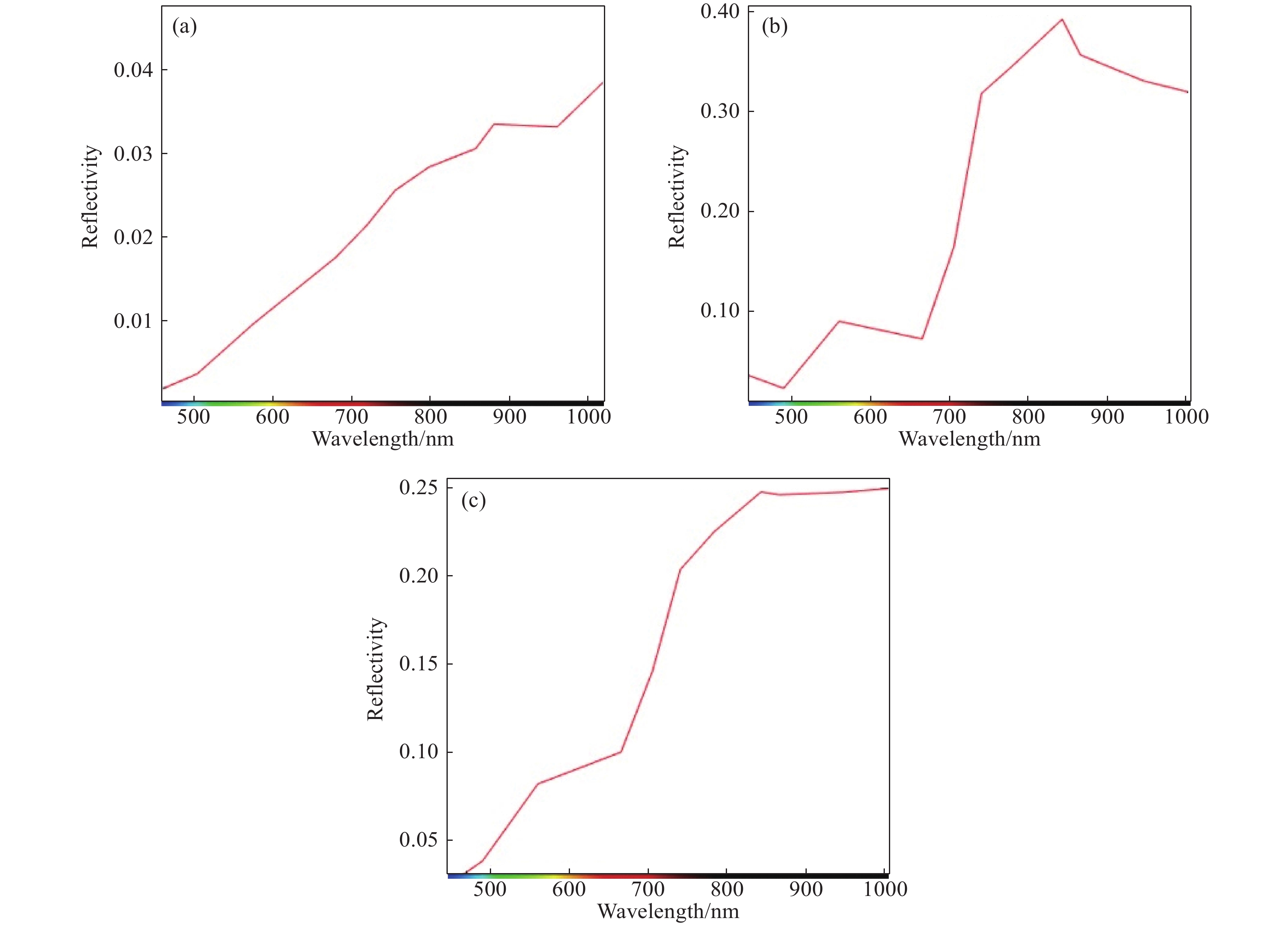
圖 4 勝利礦區各區域抽樣光譜曲線.(a)誤差區域;(b)人工恢復區域;(c)自然植被區域
Figure 4. Sampling spectrum curve of each area in Shengli mining area: (a) error area; (b) artificial restoration area; (c) natural vegetation area
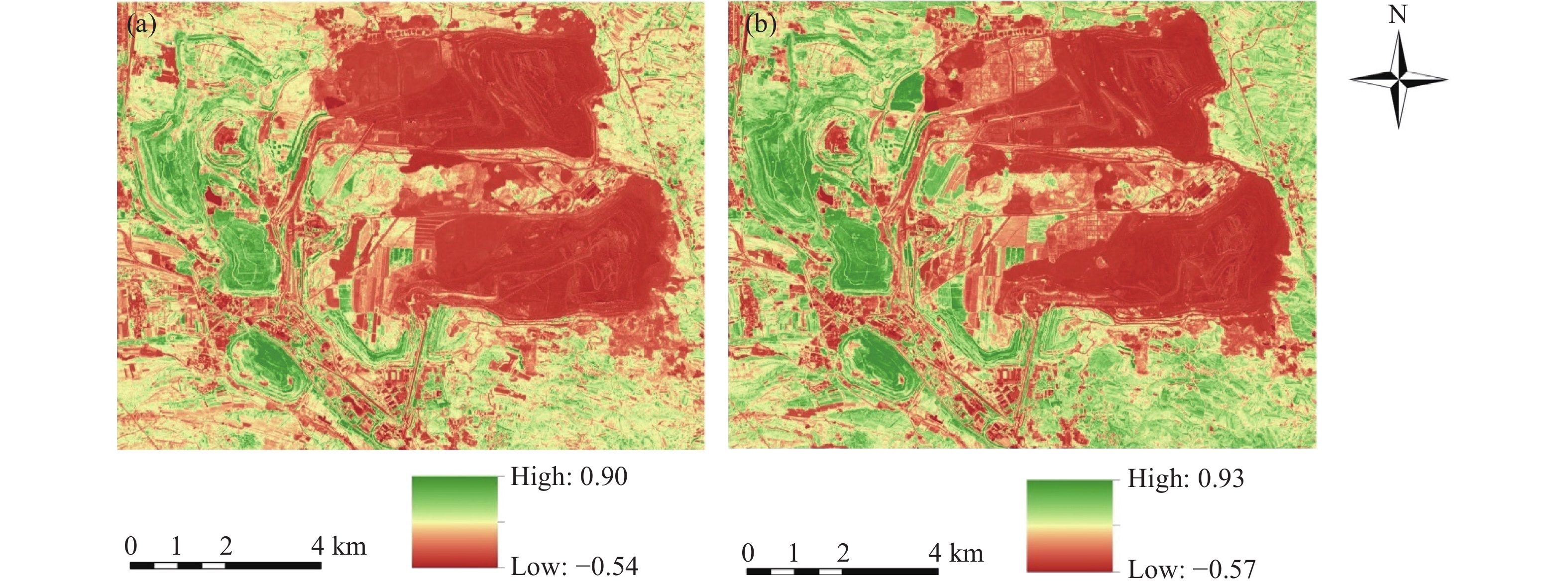
圖 5 平朔礦區NDVI分布.(a)2019年;(b)2020年
Figure 5. NDVI distribution in Pingshuo mining area: (a) 2019; (b) 2020
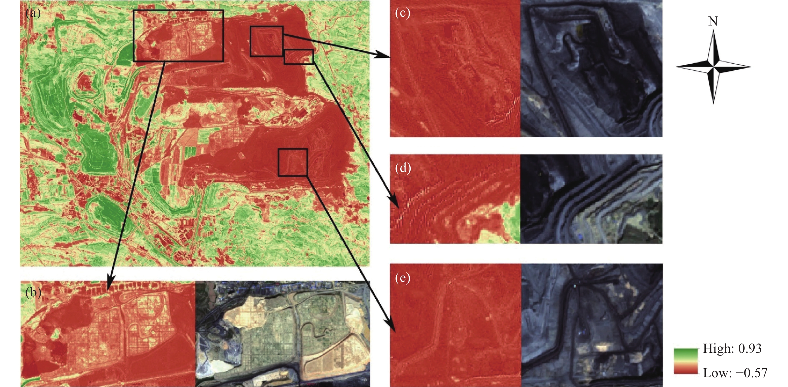
圖 6 2020年平朔礦區NDVI誤差區域與人工修復區域對比.(a)2020年平朔礦區NDVI分布;(b)近期植被恢復區域;(c)誤差區域示例1;(d)誤差區域示例2;(e)誤差區域示例3
Figure 6. Comparison of NDVI error area and manual restoration area in Pingshuo mining area in 2020: (a) NDVI distribution in Pingshuo mining area in 2020; (b) recent vegetation restoration area; (c) error area example 1; (d) error area example 2; (e) error Area example 3
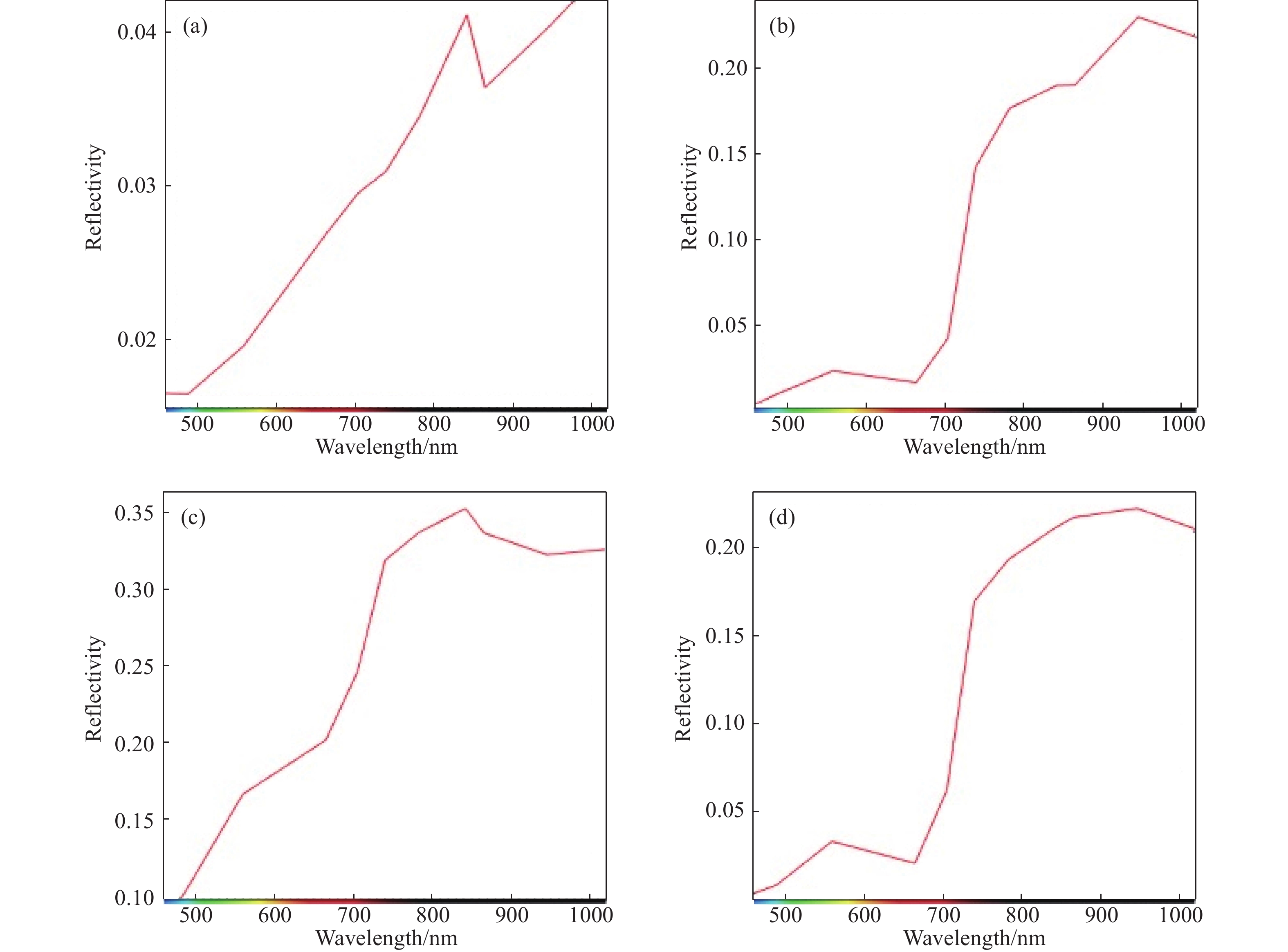
圖 7 平朔礦區各區域抽樣光譜曲線.(a)誤差區域;(b)植被恢復完成區域;(c)近期植被恢復區域;(d)自然植被區域
Figure 7. Sampling spectrum curve of each area in Pingshuo mining area: (a) error area; (b) vegetation restoration completed area; (c) recent vegetation restoration area; (d) natural vegetation area
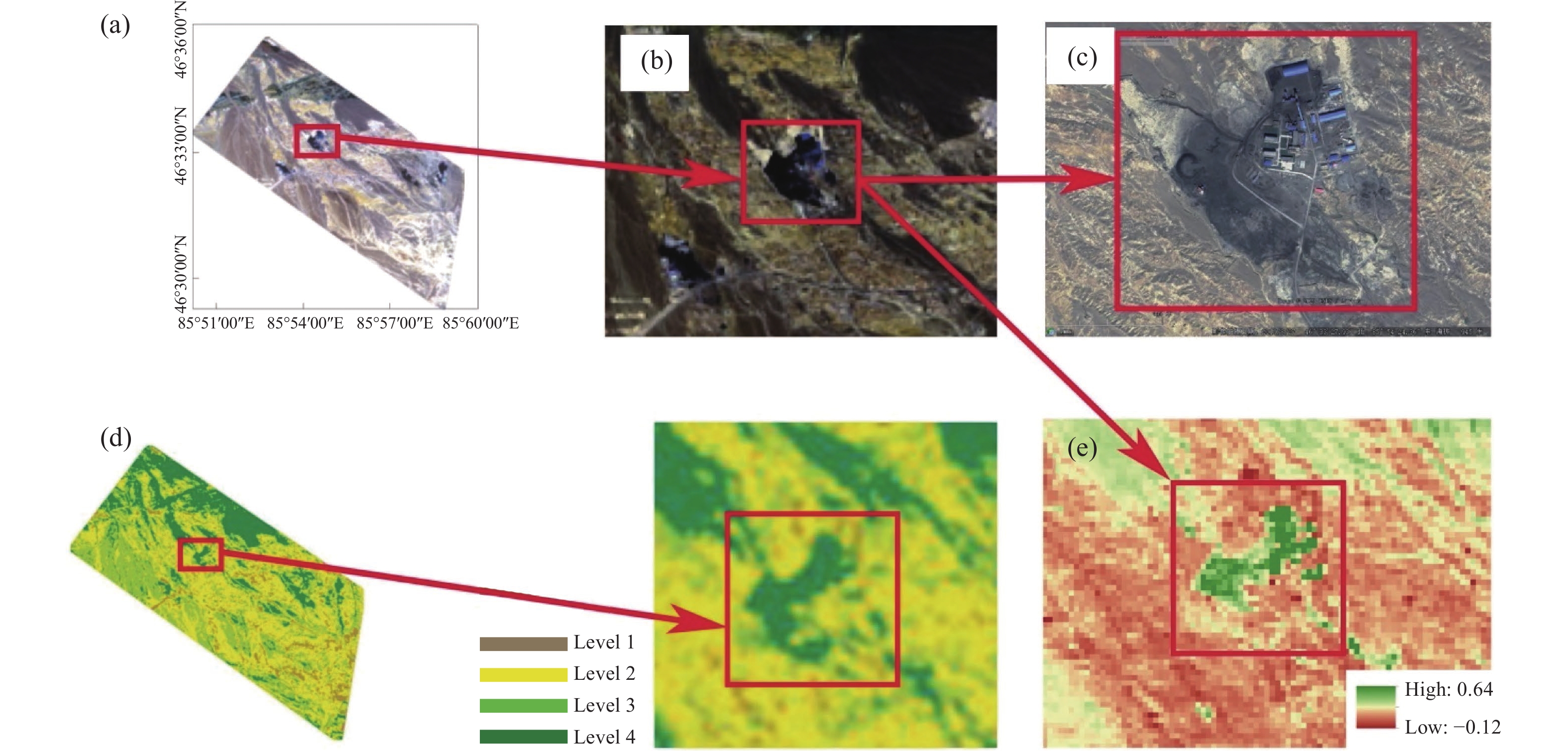
圖 8 其他研究成果中的“NDVI的礦區歸一化誤差”現象[2].(a)原文研究地區;(b)Landsat 8OLI影像(2019年6月1日,真彩色合成);(c)Google Earth高清影像(2019年8月27日);(d)原文植被覆蓋度分布(2019年);(e)NDVI
Figure 8. Phenomenon of "NDVI mining area normalization error" in other research results[2]: (a) research area in the citation; (b) landsat 8OLI image (June 1, 2019, true color composite); (c) Google earth image (August 27, 2019); (d) distribution of vegetation coverage in citations (2019); (e) NDVI
表 1 遙感數據信息
Table 1. Remote sensing data information
Study area Satellite Imaging time Spatial
resolution/mShengli Coal Mine Sentinel-2A 7, July, 2019 10 Shengli Coal Mine Sentinel-2B 21, August, 2019 10 Shengli Coal Mine Sentinel-2A 15, September, 2019 10 Shengli Coal Mine Sentinel-2A 14, July, 2020 10 Shengli Coal Mine Sentinel-2A 25, August, 2020 10 Shengli Coal Mine Sentinel-2A 19, September, 2020 10 Pingshuo Coal Mine Sentinel-2B 17, September, 2020 10 Pingshuo Coal Mine Sentinel-2A 8, October, 2019 10  下載: 導出CSV
表 2 不同區域NDVI計算參數均值
Table 2. Calculation parameters of NDVI in different areas
Parameters Error zone Artificial recovery area Natural vegetation 2020 2019 2020 2019 2020 2019 NIR 0.030 0.050 0.195 0.360 0.321 0.461 R 0.016 0.014 0.065 0.153 0.207 0.095 NIR–R 0.014 0.018 0.130 0.104 0.114 0.183 NIR+R 0.046 0.032 0.259 0.257 0.527 0.278 NDVI 0.313 0.287 0.501 0.432 0.216 0.206
下載: 導出CSV
www.77susu.com<span id="fpn9h"><noframes id="fpn9h"><span id="fpn9h"></span> <span id="fpn9h"><noframes id="fpn9h"> <th id="fpn9h"></th> <strike id="fpn9h"><noframes id="fpn9h"><strike id="fpn9h"></strike> <th id="fpn9h"><noframes id="fpn9h"> <span id="fpn9h"><video id="fpn9h"></video></span> <ruby id="fpn9h"></ruby> <strike id="fpn9h"><noframes id="fpn9h"><span id="fpn9h"></span> -
參考文獻
[1] Liu Y, Lei S G, Chen X Y, et al. Temporal variation and driving factors of vegetation coverage in Shendong central mining area based on the perspective of guided restoration. J China Coal Soc, 2021, 46(10): 3319劉英, 雷少剛, 陳孝楊, 等. 神東礦區植被覆蓋度時序變化與驅動因素分析及引導恢復策略. 煤炭學報, 2021, 46(10):3319 [2] Patiguri R Z, Chai S Q, Halembek M, et al. Dynamic changes and trends forecast of surface vegetation coverage in Heshituoluogai Mining Area of Northern Junggar Coalfield. China Energy Environ Prot, 2020, 42(12): 1帕提古麗·如則, 柴雙奇, 哈力木別克·滿太西汗, 等. 準北煤田和什托洛蓋礦區植被覆蓋度動態變化與趨勢預測. 能源與環保, 2020, 42(12):1 [3] Hui J W, Bai Z K, Ye B Y, et al. Remote sensing monitoring and evaluation of vegetation restoration in grassland mining areas—a case study of the shengli mining area in Xilinhot City, China. Land, 2021, 10(7): 743 doi: 10.3390/land10070743 [4] Wang G F, Bi R T, Zhang W P, et al. Temporal and spatial distribution characteristics and influencing factors of vegetation coverage in typical mining areas. Acta Ecol Sin, 2020, 40(17): 6046王國芳, 畢如田, 張吳平, 等. 典型礦區植被覆蓋度時空分布特征及影響因素. 生態學報, 2020, 40(17):6046 [5] Rouse J W, Haas R H, Schell J A, et al. Monitoring vegetation systems in the Great Plains with ERTS//Proceedings of the Third Earth Resources Technology Satellite ERTS Symposium. Washington D C, 1974 [6] Tian Q J, Min X J. Advances in study on vegetation indices. Adv Earth Sci, 1998, 13(4): 327 doi: 10.3321/j.issn:1001-8166.1998.04.002田慶久, 閔祥軍. 植被指數研究進展. 地球科學進展, 1998, 13(4):327 doi: 10.3321/j.issn:1001-8166.1998.04.002 [7] Ma X L, Wang X F, Chen M, et al. Analysis on the change of the vegetation coverage degree based on NDVI in Shendong coal mine areas. J Anhui Agric Sci, 2011, 39(21): 12795 doi: 10.3969/j.issn.0517-6611.2011.21.057馬曉黎, 王行風, 陳明, 等. 基于植被指數的神東礦區植被蓋度變化分析. 安徽農業科學, 2011, 39(21):12795 doi: 10.3969/j.issn.0517-6611.2011.21.057 [8] Zhen N, Li Y H, Chen T. Dynamic change analysis of vegetation coverage in mining area of Yuzhou City from 1992 to 2015. Geospat Inf, 2021, 19(5): 91 doi: 10.3969/j.issn.1672-4623.2021.05.025甄娜, 李宇航, 陳濤. 禹州市1992—2015年礦區植被覆蓋度動態變化研究. 地理空間信息, 2021, 19(5):91 doi: 10.3969/j.issn.1672-4623.2021.05.025 [9] Wu C Q, Zhang X B, Wang Y, et al. Analysis of vegetation coverage extraction and time-space change in Muli coalfield based on landsat image. Geomat &Spatial Inf Technol, 2020, 43(2): 67 doi: 10.3969/j.issn.1672-5867.2020.02.020伍超群, 張緒冰, 王耀, 等. 基于Landsat影像的木里煤田礦區植被覆蓋提取及時空變化分析. 測繪與空間地理信息, 2020, 43(2):67 doi: 10.3969/j.issn.1672-5867.2020.02.020 [10] Sha R N. Analysis of temporal and spatial variation of vegetation cover in wulatehouqi based on NDVI. For Resour Manag, 2017(6): 89莎日娜. 基于NDVI的烏拉特后旗植被覆蓋度時空變化分析. 林業資源管理, 2017(6):89 [11] Wang K W, Li J, Wang R G, et al. Spatial heterogeneity monitoring of temporal variation of vegetation coverage in Shengli mining area. Bull Surv Mapp, 2020(11): 1王科雯, 李晶, 王瑞國, 等. 勝利礦區植被覆蓋度時序變化的空間異質性監測. 測繪通報, 2020(11):1 [12] Qiu J, Zhang Y L, Li M S. Spectral characteristics analysis on forest vegetation recovery: A case study of mufu mountain mining area. Remote Sens Inf, 2020, 35(3): 122邱潔, 張亞麗, 李明詩. 森林植被恢復光譜特征分析——以幕府山礦區為例. 遙感信息, 2020, 35(3):122 [13] Li S J, Wang J M, Zhang M. Characterizing and attributing the vegetation coverage changes in North Shanxi coal base of China from 1987 to 2020. Resour Policy, 2021, 74: 102331 doi: 10.1016/j.resourpol.2021.102331 [14] Maneja R H, Miller J D, Li W, et al. Long-term NDVI and recent vegetation cover profiles of major offshore island nesting sites of sea turtles in Saudi waters of the northern Arabian Gulf. Ecol Indic, 2020, 117: 106612 doi: 10.1016/j.ecolind.2020.106612 [15] Zoungrana B J B, Conrad C, Thiel M, et al. MODIS NDVI trends and fractional land cover change for improved assessments of vegetation degradation in Burkina Faso, West Africa. J Arid Environ, 2018, 153: 66 doi: 10.1016/j.jaridenv.2018.01.005 [16] Hossain M L, Li J F. NDVI-based vegetation dynamics and its resistance and resilience to different intensities of climatic events. Glob Ecol Conserv, 2021, 30: e01768 doi: 10.1016/j.gecco.2021.e01768 [17] Carlson T N, Ripley D A. On the relation between NDVI, fractional vegetation cover, and leaf area index. Remote Sens Environ, 1997, 62(3): 241 doi: 10.1016/S0034-4257(97)00104-1 [18] Zaitunah A, Samsuri, Sahara F. Mapping and assessment of vegetation cover change and species variation in Medan, North Sumatra. Heliyon, 2021, 7(7): e07637 doi: 10.1016/j.heliyon.2021.e07637 [19] Xu Xia, Sun Wenbin, Wang Zhen. Analysis of soil moisture changes of the Buertai mining area based on TVDI. J Mining Sci Technol, 2019, 4(4): 285徐霞, 孫文彬, 王振. 基于TVDI的布爾臺礦區土壤濕度變化分析. 礦業科學學報, 2019, 4(4):285 [20] Wang W, Liu R Y, Gan F P, et al. Monitoring and evaluating restoration vegetation status in mine region using remote sensing data: Case study in Inner Mongolia, China. Remote Sens, 2021, 13(7): 1350 doi: 10.3390/rs13071350 [21] Dou Y J, Wang R H, Fu H P, et al. Spatiotemporal variation and driving forces of NDVI in Shanxi province. J Shanxi Univ (Nat Sci Ed),doi: 10.13451/j.sxu.ns.20211131竇永靜, 王讓虎, 付含培, 等. 山西省植被NDVI時空變化及驅動力研究. 山西大學學報(自然科學版),doi: 10.13451/j.sxu.ns.2021113 [22] Cai M F, Wu Y Q, Li P, et al. Present situation and ideas of green development of coal resources in Ningxia Province. Chin J Eng, 2022, 44(1): 1蔡美峰, 吳允權, 李鵬, 等. 寧夏地區煤炭資源綠色開發現狀與思路. 工程科學學報, 2022, 44(1):1 [23] Xing Y, Zhang W B, Su W, et al. Research of ultra-low emission technologies of the iron and steel industry in China. Chin J Eng, 2021, 43(1): 1邢奕, 張文伯, 蘇偉, 等. 中國鋼鐵行業超低排放之路. 工程科學學報, 2021, 43(1):1 [24] Guo N. Vegetation index and its advances. J Arid Meteorol, 2003, 21(4): 71郭鈮. 植被指數及其研究進展. 干旱氣象, 2003, 21(4):71 [25] Yang K M, Guo D Z, Chen Y H. Analysis of vegetation spectral features based on hyperspectral imaging data. Comput Eng Appl, 2006, 42(31): 213 doi: 10.3321/j.issn:1002-8331.2006.31.063楊可明, 郭達志, 陳云浩. 高光譜植被遙感數據光譜特征分析. 計算機工程與應用, 2006, 42(31):213 doi: 10.3321/j.issn:1002-8331.2006.31.063 [26] Clevers J G P W. The application of a vegetation index in correcting the infrared reflectance for soil background. Symp Rem Sens Res Dev Envir Management,Enschede, 1986, 26: 221 -

 點擊查看大圖
計量
- 文章訪問數: 535
- HTML全文瀏覽量: 175
- PDF下載量: 57
- 被引次數: 0
